|
The fundamental work of a geographer begins by describing location. Locational reference systems have been created to accurately identify the location of earth phenomena.
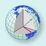
Figure 1.31 The Geographic Grid: Latitude and Longitude (Courtesy The National Atlas)
Latitude and longitude comprises a grid system of
lines encircling the globe and is used to determine the locations of points on the
earth. Lines of latitude, also called
parallels, run east - west. Latitude lines
always run parallel to each other, and hence, they are always an equal distance apart.
Latitude lines never converge or cross. 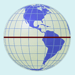
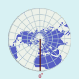
Figure 1.32 The Equator (Courtesy The National Atlas)
Lines of latitude measure distance north or south of the equator. The latitude of a
particular location is the distance, measured in degrees, between that place and the
equator along a meridian, or line of longitude. The equator is 0o latitude, and the North and South Poles are located at 90o north and 90o south latitude respectively. In other words, values for latitude range from a minimum of 0o to a maximum of 90o.
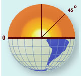
Figure 1.33 Measuring Latitude. (Courtesy The National Atlas)
If the earth
were a perfect sphere (which it isn't), the distance, or the length, of 1o of
latitude would be constant everywhere. In reality, the earth is slightly flattened at the
poles, so the length of 1o of latitude at the poles is slightly more than at
the equator. At the equator, the length of 1o of latitude is equal to 110.6 km
(68.7 mi.) and at the poles, the length of 1o of latitude is equal to 111.7 km
(69.4 mi.). For our purposes, we will assume the length of one degree of latitude is 111
km.
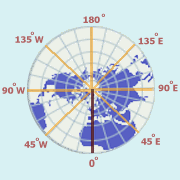 Figure 1.34 Longitude (Courtesy The National Atlas)
Lines of longitude, also called meridians, run north - south. Meridians are
farthest apart at the equator, and converge at the North and South Poles. Lines of longitude measure distance east or west of the prime meridian. The longitude
of a particular location is the distance along a parallel, measured in degrees, between
that place and the prime meridian. The prime meridian passes through the old Royal
Observatory at Greenwich, England, and is sometimes referred to as the Greenwich meridian.
Since meridians are farthest apart at the equator and converge at the poles, the distance
in kilometers (or miles) of 1o of longitude varies from a maximum at the
equator, to a minimum at the poles. At the equator the approximate length of 1o
is approximately 111 km (69 mi.). At 60o north and south latitudes, the length
of 1o of longitude is approximately 55.5 km (34.5 mi.), or half what it is at
the equator.
Figure 1.35 The prime meridian (Courtesy The National Atlas)
 The prime meridian, which runs through Greenwich, England, is referred to as 0o longitude. Points are measured east or west of the prime meridian until one reaches the
opposite side of the prime meridian, which is referred to as the International Date Line.
This is considered 180o longitude, and is the highest value which longitude can
take. In other words, values for longitude range from a minimum of 0o to a
maximum of 180o. The prime meridian, which runs through Greenwich, England, is referred to as 0o longitude. Points are measured east or west of the prime meridian until one reaches the
opposite side of the prime meridian, which is referred to as the International Date Line.
This is considered 180o longitude, and is the highest value which longitude can
take. In other words, values for longitude range from a minimum of 0o to a
maximum of 180o.
An infinite number of parallels or meridians can be drawn on a globe. Thus, parallels
and meridians exist for any point on the earth. Generally, only selected parallels and
meridians are marked on maps and globes, and these are usually spaced equal distances
apart. Parallels and meridians always intersect each other at right angles. In order to
locate a particular point on the earth, a latitude and a longitude measurement is
necessary. As stated above, these measurements are in degrees, but sometimes measurements
smaller than degrees are necessary. In this case, minutes and seconds are used.
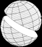
When we travel, we usually like to take the shortest route between two locations. If you pass a plane through the center of a sphere, the
intersection of the plane and the surface of the sphere creates a great
circle. Planes passing through any other part of a sphere without
going through the center create small circles. An arc of a great circle
is the shortest distance between two points on a sphere and therefore is
the preferred route for planes traveling great distances, like crossing
an ocean. The concept of great and small circles relates to meridians
(longitude) and parallels (latitude). Meridians are half of a great
circle (180o) whose ends are at the North and South poles.
Parallels of latitude are small circles, except for the equator
which is a great circle.
For more information about other locational systems, start "Digging Deeper Into Locational Systems: USPLS and UTM" or continue reading
Previous
| Continue
|
 CONTENTS | ATLAS | GOOGLE EARTH