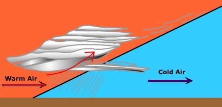
Warm Front WeatherFigure 8.17 shows the profile view of a warm front and its associated weather. The warm front slopes gently up into the troposphere that has a direct bearing on the kinds of clouds that are produced. As the warm air behind the front collides with the cooler air ahead, the warmer less dense air is forced to glide upward.
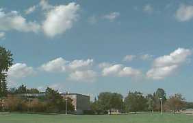
A typical sequence of clouds develops as a result of this gentle uplift. The first clouds you see as a warm front approaches are the thin, wispy cirrus clouds. As the front approaches the clouds become thicker and the cloud base lowers. As the cirrus clouds pass by you, cirrostratus and then altostratus clouds approach. As the warm front is nearly at your location you will see the clouds completely cover the sky as stratus clouds. Nimbostratus clouds along the front create low intensity precipitation that might last for a long time. Ahead of the front the wind is generally cool and from a easterly direction. As the front passes by you the wind direction shifts toward the southeast and the south. As it does the temperatures start to rise as warm air replaces the cool air at your location. Warm Sector WeatherOnce the warm front passes your location you'll notice an increase in temperature and air pressure. Soon the stratus clouds of the warm front give way to broken and clearing skies. As the warm sector moves into your location you will notice an increase in the humidity of the air. The wind is out of the south so maritime tropical air begins to invade. During the afternoon you might see an occasional puffy cumulus cloud. These "fair weather" clouds are often created by convection and instability in the warm and humid afternoon air.
After a while the winds start to shift to the southwest and the humidity continues to rise. You notice the clouds begin to grow in height, merge into larger darker masses. This indicates the air is becoming much more unstable. Once again the air pressure starts to fall. Winds begin to gust and growing cumulus clouds can be seen on the horizon. It would appear that a cold front is approaching.
|