Explaining Patterns of Air Temperature
Global patterns of air temperature are a reflection of the relative importance of sun angle and insolation intensity, day length, and location with respect to water bodies. We have found that low latitude locations experience less variation in sun angle and day length than do mid- and high latitude locations. Places located near large bodies of water tend to have more moderate temperatures than those further inland.
Mapping Patterns of Air Temperature
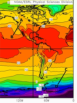
Isotherms, lines connecting points of equal air temperature are used to map the geographic pattern of temperature across the earth's surface. The spacing of isotherms depict the temperature gradient across a portion of the Earth's surface. Widely spaced isotherms (line A-B in Figure 5.12) indicate a small change in temperature over distance and closely spaced isotherms (line C-D in Figure 5.7) indicate large changes in temperature.
Figure 5.12 Isotherms and Temperature Gradient
The shape of isotherms as they appear on a map are influenced by the distribution of large land masses and water bodies and the time of the year. Follow the 10C (50F) isotherm from left to right across the Figure 5.13. During January, the water stays warmer than the land causing the 10C isotherm to shift toward the south. In July (Figure 5.14) the 10C isotherm swings to the north as we move from the cool water to the warmer land. This differential heating of land and water results in a small variation in the position of the 10C isotherm over water but a much larger variation over land.
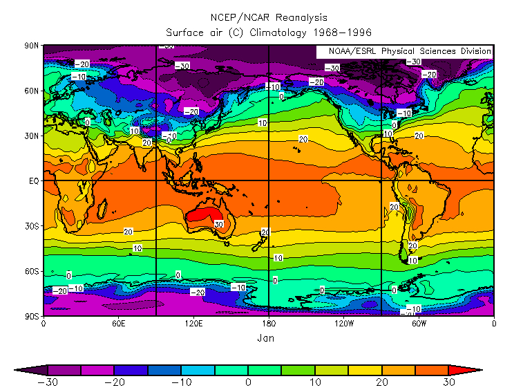
Figure 5.13 Average January Temperature
Click map to enlarge
We can certainly see the effect of differential heating of oceans and continents in the average January and July temperature maps depicted in figures 5.13 and 5.14. The isotherms are more linear (straight across) in the Southern hemisphere. Isotherms bend much more between seasons in the Northern Hemisphere than in the Southern Hemisphere. The Southern hemisphere is more uniformly water than the Northern hemisphere. Large landmasses in the Northern hemisphere cause isotherms to bend toward the equator in winter and poles in summer as they change their temperature much more than the water. Air temperatures over land fluctuate more because land changes its temperature much more rapidly than ocean water does. Thus they shift north and south much more over land through the year than they do over water.
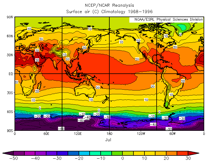
Figure 5.14 Average July Temperature
Click map to enlarge
Comparing the difference in the values of the isotherms between seasons, the smallest temperature ranges are found near the equator while the largest are found over high latitude continental interiors, Siberia for example.
The difference in temperature across latitudes is the latitudinal temperature gradient. The winter hemisphere (January for the Northern hemisphere, July for the Southern Hemisphere) has the larger temperature gradients as shown by the closely spaced isotherms. Also note that the temperature gradient is steepest in the midlatitude to subarctic geographical zones. Here is where strongly contrasting tropical and polar type air masses clash along the polar front.
