Fluvial SystemsThe Stream SystemThe fundamental unit of study for fluvial processes is the drainage basin or watershed. A drainage basin is a portion of the Earth's surface that contains a main stream and its tributaries and is bounded by a drainage divide. The drainage divide represents the boundary between adjacent drainage basins and determines into which basin precipitation flows. There is no upper or lower limit to the size of a drainage basin. We can delimit the drainage basin of the Mississippi River as most of the area east of the Rocky Mountains. The main stream is the Mississippi River and its tributaries are rivers like the Missouri, Arkansas, and Wisconsin to name just a few. Or, at a more local scale we can delimit the Wolf River basin found in central Wisconsin.
Figure 18. 1 The Drainage Basin Streams within the drainage basin are either perennial
or intermittent in flow. Perennial streams flow all year. The base flow
of these streams is provided by groundwater seepage into the channel.
Tributary streams are small streams that enter
into the main stream. Tributary streams, especially the smaller ones around the
periphery of the basin, are intermittent. Intermittent streams
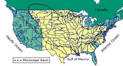
Figure 18.2 Mississippi River Basin The famous geographer John Wesley Powell recognized the value of
the watershed concept in environmental planning. In 1878 Powell published his
Report on the Lands of the Arid Region, which propose a strategy for
settling the western United States without fighting over limited water
resources. All Things Considered's Howard Berkes reports "Powell's
knowledge of the region convinced him that water, or the lack of it, would be a
major and ongoing problem in America's westward expansion."
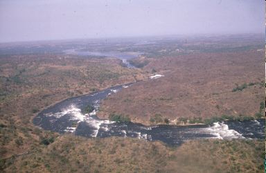
Figure 18.3 The Victoria Nile, near Murchison Falls in northern Uganda. (Courtesy K. Dunn, FAO_17389) Some streams are classified as exotic streams. Exotic streams are those that originate in a humid region but flow through an arid region. Such is the case of the Nile and Colorado Rivers. The headwaters of the Nile River is in the wet Ethiopian Highlands, and travels through the eastern portion of the Sahara Desert on its way to the Mediterranean Sea. Along its route, the river loses substantial amounts of water to evaporation. The same is true for the Colorado River. With its headwaters in the Rocky Mountains, it flows south and west towards the southwest desert of the United States. During its journey it loses nearly half its flow to evaporation. The Colorado used to flow to the ocean, astonishingly it no longer does. The reason is that the remaining water has been diverted for agriculture and municipal water use.
|

