Channel Geometry and Flow CharacteristicsChannel GeometryChannel geometry and characteristics of stream flow are inherently related. Changes in the geometry of the channel can impact stream velocity and discharge.
The cross-sectional area of the stream is determined by multiplying channel depth by channel width along a transverse section of the stream. For a hypothetical stream with a rectangular cross-sectional shape (a stream with a flat bottom and vertical sides) the cross-sectional area (A) is simply the width multiplied by the depth:
The wetted perimeter is the portion of the channel that is "wet". The wetted perimeter (WP) is the width plus twice the depth that the water touches: WP= W + 2D The greater the cross-sectional area in comparison to the wetted perimeter, the more freely flowing will the stream be because less of the water is in proximity to the frictional bed. So as hydraulic radius increases so will velocity (all other factors being equal). Studies have shown that width and depth tend to vary regularly with stream discharge. If discharge is held constant and width decreases, then the channel should deepen by scouring. This occurs as a result of the increased velocity and transportation power which accompanies the narrowing of a channel. Studies have also shown that as mean discharge of a stream increases downstream so do channel width, depth, and average current velocity. The flow velocity is directly related to the hydraulic radius (cross-sectional area divided by the wetted perimeter) and channel slope, and inversely related to channel roughness. Channel slope or gradient is the difference in elevation between two points on a stream divided by the distance between them measured along the stream channel. The flow velocity, and thus power of the stream to do work is also directly related to the slope of the channel, the steeper the slope, the faster the velocity of flow. Stream FlowSources of Stream FlowThere are four basic sources of stream flow. Groundwater flow into the channel is what provides for the base flow, or normal flow of the stream. For perennial streams the water table is at the height of the surface of the stream as shown below. The base flow of the stream is augmented by interflow from the soil moisture zone. At the surface, direct channel precipitation and surface runoff as overland flow contribute to stream flow during and following storms.
Figure 18.13 Sources of Stream Flow Flow velocity
The flow velocity of a stream is how fast the water is moving through a cross-section. Flow velocity is determined by the balance between the down slope gravitational stress as a result of the slope of the stream, and the loss or expenditure of energy in overcoming the frictional resistance of the channel bed and side. In general, the flow velocity is greatest at the center of the channel, just below the surface. More specifically the highest velocity of flow follows the stream thalweg, a line that connects the deepest part of the stream channel. Here, water moving through the stream encounters the least resistance to flow yielding a higher velocity of flow.
Figure 18.15 Streamgage: The Silent Superhero Flow RegimesUnder very low velocities water flows through a stream as smooth sheets running parallel to the bed called laminar flow. Laminar flow has an appearance much like that of a deck of cards with the top card jutting forward over those below. The tug of the channel bottom slows the water near the bed with the water nearer the surface flowing somewhat faster. Only the finest particles kind be detached, so laminar flow is basically nonerosive. Under higher flow velocities, resistance within the flow and that caused by the bed and sides of the channel cause the flow to break down into separate currents. The swirling currents of turbulent flow undergo constant variation in speed and direction of flow. The swirls of water created during turbulent flow are more erosive than laminar flow and help suspend material in the stream. Turbulent flow is the "normal" type of flow in most streams.
No image available Figure 18.16 Laminar and turbulent flow Stream dischargeStream discharge is the volume of water passing through a particular cross-section in a unit of time, measured in units like cubic meters per second or cubic feet per second. The discharge of a perennially flowing stream is provided by the influx of groundwater into the channel. This influx provides what is called the "base flow" of the stream. Water is added to the stream by runoff from the surrounding terrain during storm events. Discharge(Q) can be expressed as Q = A X V where,
The hydrograph is a graphical way of portraying the change in discharge over time, and how it relates to inputs of water and the environment in which the stream is located. The Y-axis of the hydrograph is scaled for discharge, and when investigating the influence of a storm event, precipitation. The X-axis is scaled for time. Discharge is plotted as a line and precipitation as a bar graph. The hydrograph shows discharge starting at its base flow, rising to a peak (the rising limb) and then declining (recessional limb) back to its base flow. Notice how the peak in precipitation does not occur at the same time as the peak in discharge. In other words, there is a lag period between the time when the most precipitation occurs and when the most discharge is recorded. A number of factors influence the shape of the hydrograph and the length of the lag period. Elongate basins tend to exhibit flatter hydrographs because it takes a longer time for water to move from the head to the recording station at the mouth of the basin. Travel time is less for circular basins resulting in a more peaked hydrograph.
Land cover is another important control over the shape of a stream hydrograph. Under natural conditions, vegetation slows surface runoff and encourages infiltration. As a result, the hydrograph is less peaked and the lag time is longer than a basin with little vegetation. Urbanization of a watershed can have a drastic effect on runoff, discharge, and the resulting hydrograph. Urbanization replaces permeable surface with impermeable ones, streets, parking lots, buildings etc. Water runs off the surface more efficiently and is diverted to nearby streams by the construction of storm sewers. Storm sewers effectively increase the urbanized watershed drainage density. As a result, urbanized watersheds tend to exhibit more peaked hydrographs with shorter lag periods. Stream energyThe energy that a stream possesses is closely related to its discharge because discharge determines flow velocity. Flow velocity controls the stream's capacity to erode and transport sediment through its channel. Generally, the larger the discharge, the smoother the channel, greater the stream velocity. Cross-sectional area and discharge increases down stream due to tributary and ground water flow into the channel. As a result, one might expect flow velocity to increase in the down stream direction as well. However, as streams grow larger their down stream slope decreases, preventing a continuous buildup of energy and creating a more uniform distribution of stream energy along its length.
|
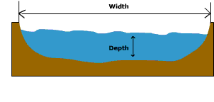 Figure 18.12 Cross-sectional
area.
Figure 18.12 Cross-sectional
area.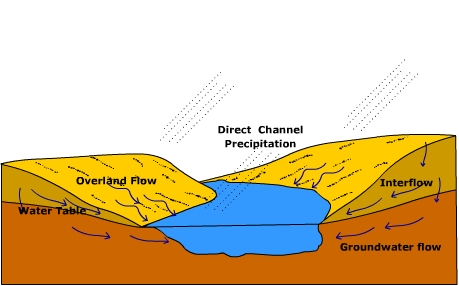
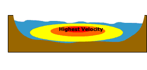 Figure 18.14 Flow velocity
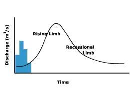 Figure 18.17 A
stream hydrograph
Figure 18.17 A
stream hydrograph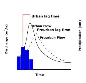 Figure 18.18 Comparison of pre-urban and post-urban watershed discharge.