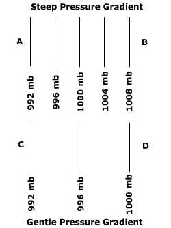
Controls over wind direction and speedAir is constantly moving to seek an equilibrium between areas of more air molecules (higher pressure) and those with less (lower pressure). You have probably experienced this by opening a container that has been vacuum packed. Because the container is vacuum packed, there is less air inside the can (lower pressure) than outside the can (higher pressure). When you open the container you here a "whoosh" as air rushes into it. The air rushing from outside the container into it is a wind, albeit at the microscale. Wind is nothing more than the movement of air molecules from one place to the next. The direction and speed of the wind represents the balance between three basic forces acting on it: the pressure gradient, the Coriolis force, and surface friction. Pressure GradientThe spacing of isobars indicates the change in pressure over distance otherwise known as a pressure gradient. We can induce a change in pressure over distance by the unequal heating of the Earth's surface. This can be done when one location receives more incoming energy than another, possibly because one place has a higher sun angle than another. Heating the air in one place causes it to rise off the surface promoting low pressure with the pressure increasing away from that location. The creation of a pressure gradient initially causes the air to flow from higher toward lower pressure creating a wind. So in terms of a cause-and-effect relationship: Energy gradient -> temperature gradient -> pressure gradient -> wind Go to the pressure gradient animation to see how pressure gradients at, and above, the surface are formed. The orientation or direction of a pressure gradient is always described as being from higher toward lower pressure. The speed of the wind is controlled by the strength of the pressure gradient, the stronger the pressure gradient the higher the wind speed. The strength of the pressure gradient can be discerned from the spacing of isobars on a weather map. Figure PC.4 shows two different pressure gradients. The distance between points A and B and C and D are the same but the amount of pressure change is quite different. You can tell that the pressure gradient is greater between A and B because the spacing of the isobars is much closer than between C and D. As a result, the wind blows much faster between A and B. Figure 6.8 Isobar spacing and pressure gradient.
|